EIA AIRPORT OF THE PACIFIC

The work carried out consisted of the preparation of the Environmental Impact Assessment in accordance with the terms of reference issued by the Ministry of the Environment and Natural Resources (MARN), which include: Description of the project and its alternatives. Study of the legal and environmental regulations applicable to the activity. Description, characterization and quantification […]
ENVIRONMENTAL ZONING IN THE NORTH-EASTERN ZONE OF EL SALVADOR

Multisectoral and integrated territorial diagnosis of the northeastern part of El Salvador at a scale of 1:25,000 including: Land use map 2016 purified and improved with field verification Sectoral Diagnostic Documents of the Northeastern Zone of El Salvador at a scale of 1:25,000: Physical (geological, soil, agrological, hydrological and hydrogeological, all aimed at identifying characteristics, […]
ENVIRONMENTAL IMPACT STUDY OF ILOPANGO INTERNATIONAL AIRPORT

The work carried out consisted of the preparation of the Environmental Impact Study according to the terms of reference issued by the Ministry of the Environment and Natural Resources (MARN), including: Description of the project and its alternatives. Study of the legal and environmental regulations applicable to the activity. Description, characterization and quantification of the […]
NATIONAL FOREST INVENTORY OF EL SALVADOR
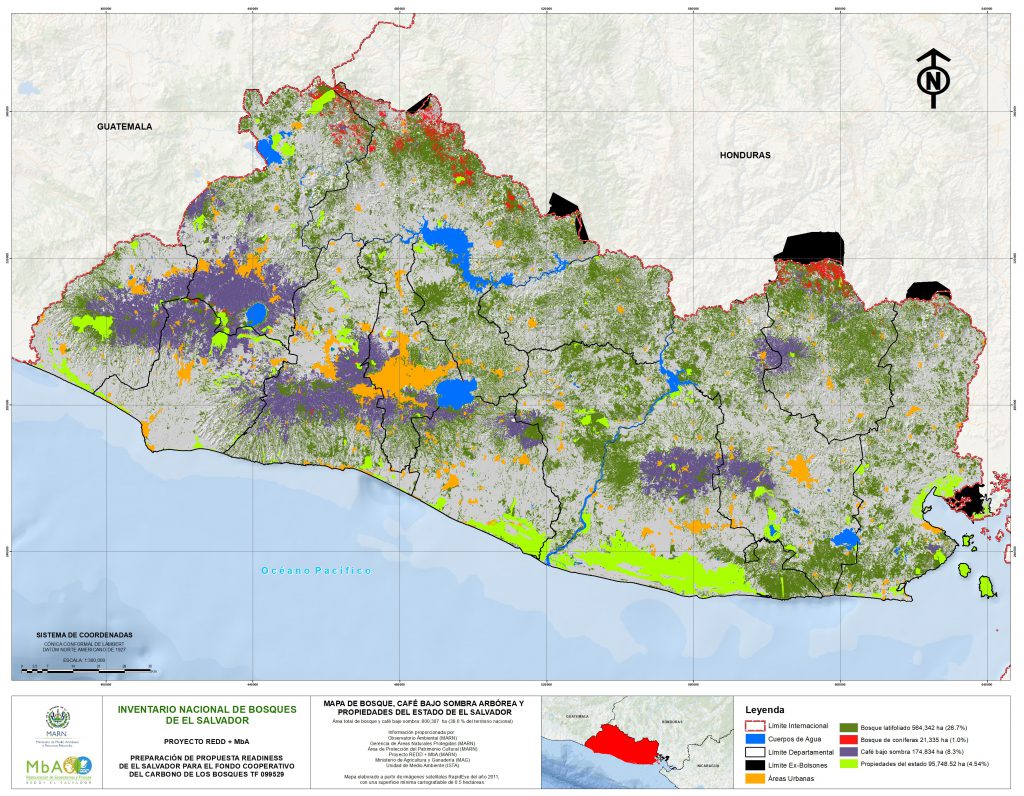
VIELCA MEDIO AMBIENTE planned, coordinated and executed the first National Forest Inventory of El Salvador, a pioneering and highly difficult task due to the country’s characteristics. A total of 270 plots of land were erected, with their corresponding social coordination, distributed among the different vegetation strata, such as secondary forest, coniferous forest, shady coffee plantations […]
ENVIRONMENTAL ZONING OF THE GULF OF FONSECA

In this work, the environmental zoning of the Unit La Unión – Gulf of Fonseca was developed, following the requirements of Salvadoran environmental legislation. For this purpose, a complete multisectoral and integrated territorial diagnosis was carried out on a scale of 1:25.000, including a land-use map and the implementation of a probe made for the […]